Applying the right method and practice to a districting exercise
Identifying the most pertinent method via some illustrated examples

Workshop led by Alexandra Gomez
This workshop will follow the stages outlined below:
Introduction: Districting analysis problematics
The term ‘districting’ implies a process of exploration of specific needs and how they manifest on the ground: for example of how deliveries, or interventions at identified visit locations with estimated workloads can be fulfilled, or of how customer portfolios, and potential prospection activity can best be served by a propitious dividing up of the territory between available resources. Add to this the taking into account of characteristics specific to different business domains, and we can see that Districting involves as much a logistics-oriented representation of delivery or intervention zones, as it does definition of areas of coverage or business sectors.
These heterogeneous needs are conditioned by various constraints: logistical, human, historical (location of resources or depots, customer relationships that must be safe-guarded, contractual obligations with respect to management, skills considerations…) but underlying the exercise is the overall objective to optimise the way we cover a given territory, while reducing the time devoted to travelling between locations.
One methodological starting point is to make the distinction between districting and assignment, so we begin by asking the question: to what must the «sectors» of activity that we are seeking to optimise correspond?
- If our aim is the assignment of a series of points marking known visit points, without applying this assignment in relation to reference territories, with a view to improving the operational efficiency of resources globally, we need to adopt a «districting» method for points or assignment;
- If, on the other hand, our aim is to define a districting operation based on reference territories (towns, postal zones) to enable allocation of responsibility for each territorial area to one staff member to improve market coverage, we need to adopt a «districting» method to divide up the geographical space.
In other respects, the data available to us that we wish to bring into the analysis can also determine districting choices:
- Districting of points or assignment is relevant when we have a series of customer points at our disposal (visits, prospects…) that can be localised precisely, and for which the workload they represent is known;
- Districting of territories is pertinent when we have precise customer data (localisable) but that we also wish to combine with prospection potential, sales volumes or workload history, this data being available at the scale of towns, postal zones, or indeed at the level of any other territorial breakdown.
Now let’s look at some examples of how these different methods might be used to tackle a typical districting exercise.
Phase 1 – Structuring sectors of intervention: assigning points to visit
The aim is to work on a series of visit locations (customers, prospects, interventions) that will be regrouped in a single sector, without taking into consideration a precise territorial boundary. The priority is to give precedence to the proximity between points and minimise travel time, while ensuring a balance in workload throughout the districting configuration. These sectors can, if required, be optimised in relation to the location of a given resource. For this type of analysis, we refer to ‘allocation’ or ‘assignment’ of points.
Scenario
On the region of Bretagne in North Western France, we have a series of points representing visits to be made. Each point represents a workload that will have an impact on its weighting within a sector. It expresses a global cost in time that takes into account the time needed to make a visit, as well as the visit frequency over one year. On these points, we will, of course still have at our disposal any information about the assignment that is currently in force.
Above all else, we need to work on preparing and integrating our dataset. Refer to the workshop «Geomarketing toolbox» for examples relating to import and geocoding of the different points that represent customers or visits. Then we need to import the points along with the different indicators to exploit during the districting operation (in our example, workload). As we are representing an existing districting operation, don’t forget to also import any data that allows us to retrieve - for each point - its current assignment.
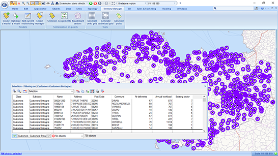
Viewing the imprint of each “sector” based on a known assignment
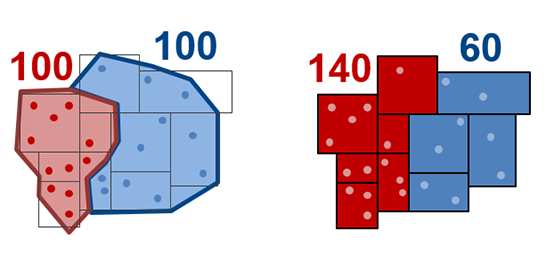
Supposing we have a field on all points visited that supplies a value for an existing assignment, it will then be possible to see clearly the different assignments as colour coded entities, and also the imprint of each group of points. The construction of the sector in this way also allows us to aggregate, on each envelope or containing entity, the cumulated pertinent data (number of points per sector, total workload, etc), so as to identify any existing imbalances.
In the scenario described, the existing situation shows a clear imbalance in terms of workload, as well as significant lack of continuity between different groups of points. From this observation, we can set out to optimise the assignment of points into seven sectors.
Creating sectors with a balanced workload
We will now construct a new districting representation, starting by creating the new assignment field on map points. For the number of sectors required, we choose seven sectors, corresponding to the number of resources needed to absorb the total annual workload. When we make the choice of criterion or criteria that must be taken into account to balance the sectors, we request only the workload criterion to be applied. Using the road network graph via the algorithm allows us to obtain sectors that are continuous, while minimising travel distance or time. Choosing to create the encompassing envelope allows to obtain the best view of the result for our purpose.
We obtain in this way a new assignment on each customer point, displayed in different colours, as well as the total workload value by sector, and the number of points in each of them. We can see on the map that there is a clear improvement to the distribution geographically, while the workload balance has been respected.
Finding the optimum siting for resources and reformulating optimised sectors
In the preceding scenario, we were able to choose to use the localisation of current resources as the criterion to take into account during the districting operation. However, in this instance, we consider that resources are not currently distributed in the best way over the territory following the departure of some staff members who will therefore need replacing. So we decide to search for the best possible recruitment pools to allow best possible coverage of the territory.
We will start by calculating the barycentre for the full set of points in each sector. Then we can search for each barycentre, in this case the nearest town with a population of more than 15,000 inhabitants. This gives us new target locations from which we can recruit our resources. We will use these identified locations to redraw our new sectors so they remain balanced in terms of workload, and optimised in relation to this localisation.
As each sector is created, it will be possible to fine-tune manually in individual cases. The impact of each alteration made is viewed on the map interactively.
Summary
Assignment of points allows us to create sectors that can be finely balanced as a function of both known visit locations (localisable) and for which we know the weighting they represent within a sector, and according to resource positioning.
This method proves to be pertinent notably for logistical districting exercises, as the sectors can constitute departure points for optimising routing to establish more precise plannings further down the line.
Phase 2 – Market prospection and local potential: districting the territory
The objective in this second phase is to create sectors from reference territories and to delimit in this way spaces within which a resource can efficiently construct their business objectives, for example if the current project is commercial prospection. Each resource will dispose, a priori, of exclusivity on their territory.
Scenario
On the region of Bretagne we dispose, on the one hand, of a series of points representing a portfolio of customers. These points are for larger customers that are to be visited at least twice annually. On the other hand, we dispose of information on potential turnover achievable on each postal zone. The customer portfolio as well as the potentials must be distributed in a balanced way between the seven members of the sales team responsible for covering the region.
It is vital – in the same way as for the preceding scenario – to prepare and integrate all useful data. Refer again to the «Geomarketing toolbox» workshop for examples related to the update of data and evaluation of numbers of customer points at postal zone level (joins).
Creating market sectors tailored to the sales force
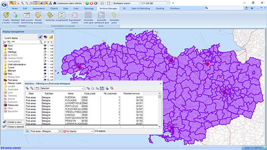
On postal zones we therefore have, for each entity, a known number of customers as well as a potential revenue figure. The objective is to rebalance sectors so as to have an equivalent distribution of customer points and potential to assign to each sector manager.
We will now create a new districting scenario, indicating which territories are to be taken into account, in this instance, postal zones. We choose to use the resources as our sector centering criteria, and we define statistical variables that must, of course, be balanced (the number of customers and the potential revenue figure).
In choosing the method, we define the one that uses focal points or ‘poles’ (resources) to define the number of sectors desired.
Following optimisation, the results can be clearly visualised as a colour range that allows us to distinguish to which sector each postal zone is attributed.
Fine-tuning a districting exercise
The summary districting table allows us to check that the right balance exists between sectors and to apply, if we wish, a few manual alterations. Dynamic recalculation on the map allows us to see the impact of each modification instantly. The detail of data associated to sectors can be easily exported so they can be retrieved in another application such as Excel.
Sectors can be created as soon as we are sure that the districting operation is satisfactory. The districting can also be re-optimised at any time if required.
Among the various methods proposed for a districting of territories, it is also possible to work from existing sectors or to define a desired number of sectors, without necessarily taking into account localisation of resources.
Summary
Districting of territories allows us to work on reference units that are not structure-dependent, and which therefore provide us with a constant referential.
This method is often deployed in steering the management of commercial prospection territories, and can also prove useful in the context of planning sectors of intervention: for example, if we dispose of average intervention times, or of historic data, such as business in the territory for year N-1.
Conclusion
While we do not claim to have conducted an exhaustive analysis of all the different districting strategies available to us, these two approaches illustrate the main lines of enquiry to use when deploying an optimisation for a business activity in any given territory.
Generally speaking, assigning points allows us to construct practical and useful districting scenarios that correctly reflect the operational reality on the ground. Regular rebalancing may be required to achieve adaptation of a business development plan to take changing workload into account. Sectors defined by territorial boundaries allow for a more informed steering of an operation, with simple and direct assignment of new customers according to their geographic localisation. However these sectors will sometimes be less finely balanced than those that are qualified or conditioned by the detail of loading on each customer point.
Each districting operation needs to be reviewed if we are to respond to changing demand. This may involve global reorganisation, with optimisation algorithms that address this demand with new calculations. Tools used to apply modifications manually make it possible to adjust existing districting exercises without applying any substantial changes. This means we can preserve links binding some resources to the territory that they know, and so guarantee continuity for a well-established marketing operation.